STORM ALERT! Powerful Tornadoes Hit Minnesota and Wisconsin
A severe storm system strikes Minnesota, Wisconsin, and Iowa, triggering tornado warnings, giant hail, and strong winds.
A severe storm system strikes Minnesota, Wisconsin, and Iowa, triggering tornado warnings, giant hail, and strong winds.
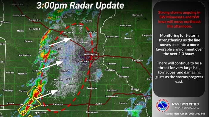
A powerful storm hits the Midwest USA this Monday (April 28), bringing a heightened risk of tornadoes, destructive winds, and giant hail. Minnesota, Wisconsin, and Iowa are on high alert. The National Weather Service (NWS) has issued a tornado watch for the Twin Cities and eastern Minnesota, with potential tornadoes reaching speeds up to 170 mph and apple-sized hail!
At 4:17 p.m., a tornado warning was issued east of St. Cloud, with strong rotation detected on radar but no confirmed funnel yet. At 4:12 p.m., rotation was also noted in Wright County with no touchdowns reported. Since 3:30 p.m., Stearns, Wright, and Meeker counties are under tornado warnings.
Minneapolis closed all public offices and canceled activities, a precaution mirrored by Brooklyn Park and Plymouth. Joe Nelson from BMTN is live streaming from St. Peter, where winds are rapidly strengthening.
The SPC (Storm Prediction Center) confirmed a 95% chance of severe tornadoes, winds of 65–80 mph, and hail up to 3.5 inches in diameter. Famous storm chaser Reed Timmer is monitoring the outbreak from Sioux Falls.
Authorities emphasize: ensure multiple alert methods and be ready to seek immediate shelter!

A series of severe storms is impacting the north-central United States, particularly in Minnesota and Wisconsin
. Weather officials have rated the storm risk as a 4 out of 5, indicating the potential for strong and long-lasting tornadoes, especially in areas such as Minneapolis, Rochester and La Crosse.
The storms are associated with supercells, which are isolated systems capable of producing significant tornadoes, large hail and damaging winds. Hailstones up to 3 inches in diameter were reported in Minnesota. In addition, a possible tornado formation was observed near Prescott, Wisconsin, around 9:55 p.m., after the storms moved eastward from the Minneapolis metro area.
The storm system is expected to continue moving east and southeast, affecting additional areas in the coming days. Officials recommend that residents remain alert for weather warnings and be prepared to seek shelter in safe locations, such as basements or interior rooms without windows, if tornado warnings are issued. For up-to-date information and real-time alerts, it is advisable to follow official National Weather Service channels and local media outlets.